London’s geology is anything but simple. Underneath the city you find London Clay, Terrace Gravels, and the Chalk Group — each with very different resistivity signatures. We run electrical resistivity and VES surveys to map these layers without a single borehole. The method is fast and non-invasive. It works well in built-up areas where digging is restricted. Before we mobilise any drilling rig, we often recommend a vs30/" data-interlink="1">MASW / Vs30 survey to complement the resistivity data for a full velocity-resistivity model of the subsurface.
A single VES profile can map the London Clay / Terrace Gravel contact at 15 m depth with ±10 % accuracy — no drilling needed.
Scope of work
- Resistivity cross-sections down to 50 m depth
- Interpreted layer boundaries (fill, gravel, clay, chalk)
- Contamination plume or groundwater table identification
Area-specific notes
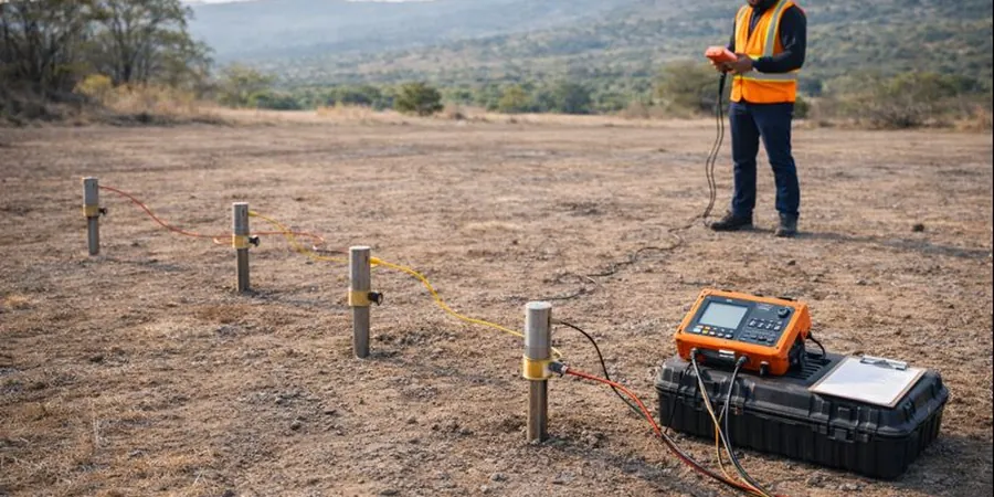
We use a 12-channel resistivity meter with stainless steel electrodes. The equipment runs on a 12 V battery pack — no generator noise in residential zones. For VES we deploy a portable transmitter-receiver unit that fits in a backpack. All cables are double-insulated for London’s wet ground. We also carry a GPS RTK unit to georeference every electrode position to ±2 cm. This is critical when working on congested sites like King’s Cross or Stratford where old utilities can distort readings.
Standards used
BS 5930:2015 – Code of practice for ground investigations, Eurocode 7 – EN 1997-1:2004 – Geotechnical design, BS 1377 – Standard guide for electrical resistivity profiling
Linked services
2D Electrical Resistivity Tomography (ERT)
Multi-electrode survey producing a continuous cross-section of subsurface resistivity. Ideal for mapping the interface between Made Ground, Terrace Gravels, and London Clay. Used for foundation design, groundwater flow modelling, and contamination delineation on brownfield sites.
Vertical Electrical Sounding (VES)
Four-electrode depth sounding at a fixed point. Each VES station provides a 1D resistivity log to 50 m depth. We deploy 5 to 10 stations per site to build a 3D resistivity model. Effective for chalk aquifer mapping and void detection under existing structures.
Typical parameters
Q&A
What is the difference between ERT and VES?
ERT (Electrical Resistivity Tomography) produces a 2D cross-section along a line of electrodes — you get lateral and vertical changes at once. VES (Vertical Electrical Sounding) gives a 1D log at a single point, with depth increasing as electrode spacing widens. ERT is better for lateral variations like buried channels; VES is faster for quick depth-to-bedrock checks.
How deep can a VES survey reach in London?
With a maximum current electrode spacing of 200 m, we can resolve layers down to about 50 m depth. In practice, the London Clay / Chalk interface at 20–40 m is well captured. Deeper targets require longer spreads and higher current, but urban sites limit the available footprint.
Can electrical resistivity detect groundwater in London Clay?
Yes. London Clay has a resistivity range of 5–20 ohm·m when saturated and 20–50 ohm·m when dry. A sharp drop below 10 ohm·m usually indicates perched water or a sand/silt lens. We correlate resistivity lows with piezometer data to confirm groundwater levels.
What is the typical cost of a resistivity survey in London?
A standard VES survey (10 stations, 50 m depth) ranges from £540 to £710 depending on access, number of electrodes, and data processing level. ERT lines cost more due to the multi-electrode setup. We provide a fixed-price quote after a site walkover.
Do you need a permit to run resistivity surveys in central London?
No permit is required from the local council for non-invasive geophysics. However, we notify the borough if electrodes are placed on public footpaths or roads. For sites near Tube tunnels or sensitive structures, we coordinate with Transport for London to avoid interference.